
– After 2,5 years of the program, it has become evident that public access to high resolution satellite images leads to more effective rainforest protection, says Norway’s Minister of Climate and Environment Mr. Espen Barth Eide.
 Photo: NASA
A game changer
Since the launch of the program in 2020, more than 18,000 registered users across the globe have made use of free, high-resolution imagery of the tropics. Even though the program has only lasted for two and a half year, feedback from governments, civil society, private sector and other users is already showing how access to updated high resolution satellite data is a game changer in understanding and responding to deforestation in the tropics.
– I am pleased to see the active use of forest governments leading the way to address deforestation, and the impactful use by indigenous peoples groups, private sector, media and others, says Norway’s Minister of Climate and Environment Mr. Espen Barth Eide.
Deforestation of tropical forests is a major cause of climate change and biodiversity loss, as well as a threat to the livelihoods of people living in and around the forest. Improved monitoring of tropical forests is crucial to quickly discover deforestation and launch effective strategies for forest protection. Historically, access to high resolution satellite data has been expensive and available only to a few actors. This is why NICFI decided to grant free access to high-resolution satellite images of the tropics to anyone, anywhere, to monitor tropical deforestation.
18,000 users from 158 countries
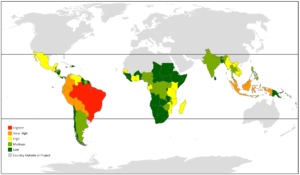
The NICFI Satellite Data Program covers all the tropical forest regions of the world. As the map shows, the majority of images are streamed in key tropical forest countries like Brazil, Colombia, Ecuador, Peru, and Indonesia.
In 2020 NICFI entered into a contract with Kongsberg Satellite Services (KSAT) and its partners Airbus and Planet to provide universal access to such images.
The NICFI Satellite Data Program has so far registered users from 158 countries around the world, using data from 97 tropical countries. And many more are accessing the data through other platforms, such as Google Earth and the Global Forest Watch.
The program applied
Forest country governments are the largest user group of the NICFI satelite program. Other important user groups are civil society, indigenous peoples, private sector, media and academia.
A recent evaluation gives insight into concrete stories of how the program is being applied:
Forest country governments are using the satellite data to discover, validate and quickly respond to changes in the forest cover, including fires. They also use the data to understand and respond to drivers of deforestation, improve planning and management, and strengthen their capacity to investigate and prosecute activities related to illegal deforestation.
Improved forest monitoring in Gabon
One example is Gabon, who is using the images from the NICFI satellite data program to improve forest monitoring of deforestation and forest degradation related to various activities and produce quarterly reports describing the status of logging and mining. This improved monitoring has helped to document cases of illegal logging, so that the government can act on it.
Better tools for mapping in Mozambique
The National Sustainable Development Fund of Mozambique is using the scenes-level data to validate deforestation events and improve forest area change estimation and mapping. Left shows the data Mozambique has access to before the program (Sentinel-based area estimations); right is improved estimation and mapping using high spatial and temporal resolution provided by the NICFI Satellite Data Program with FAO geospatial platforms.
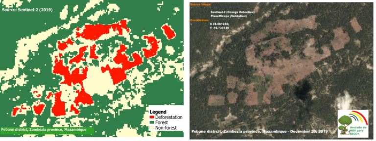 Photo: The National Sustainable Development Fund of Mozambique
Deforestation alerts in Mexico
The National Forestry Commission of Mexico reports that the imagery provided by the NICFI program has been crucial for the development, implementation, operation, and continuous improvements of an deforestation early warning system providing alerts to the National Commission of Natural Protected Areas and has led to follow up on irregular settlements and illegal trails.
Civil society organisations are using the data to support legal claims and processes, for example, related to land rights and the protection of protected areas, indigenous peoples’ rights and responding to license abuse. For example, they report illegal mining or roads that previously took longer to discover.
Near real time monitoring
Amazon Conservation has used the NICFI data for rapid & high-resolution detection of deforestation in protected areas of the Colombian, Peruvian, and Ecuadorian Amazon. The pictures below shows an area of deforestation in Chiribiquete National Park in monthly data.
 Photo: Amazon Conservation
 Photo: Amazon Conservation
Indigenous peoples controlling their territories
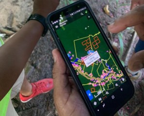 Photo: Rainforest Alliance US.
The Rainforest Foundation US facilitates training in the use of NICFI Satellite Data Program data to 5 indigenous organizations and 33 Amazonian native people from Kichwa, Shipibo and Ticuna communities. Community patrols use the basemaps on their smartphones to plan patrols to validate early deforestation alerts. The satellite images, plus the evidence gathered in the patrols, are used to identify causes of forest loss, responsible actors, and when relevant, file complaints with the government authorities.
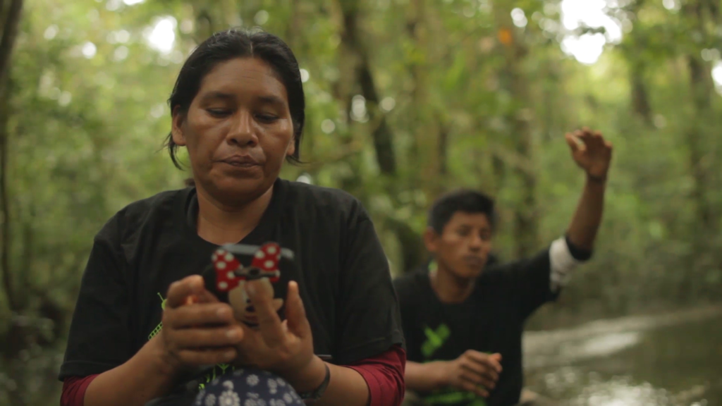 Photo: Rainforest Alliance US.
Investigative journalism document violations
The satellite data is also being actively used by media to quickly access comprehensive data on land use.
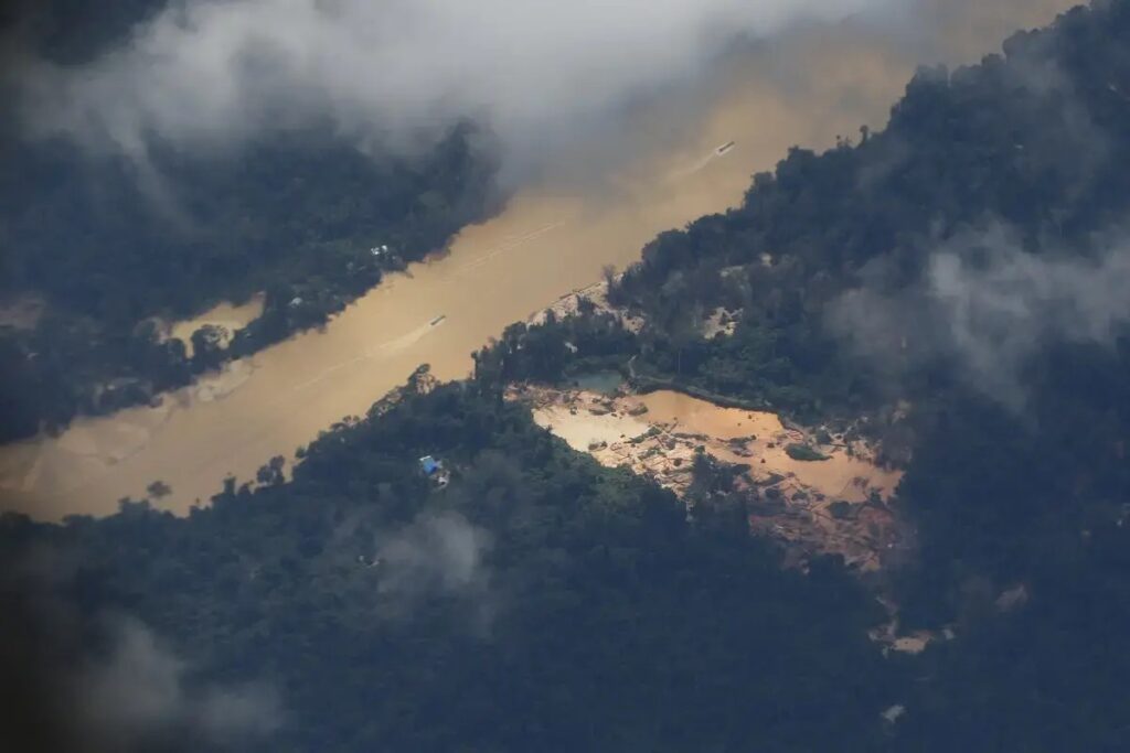 Photo: Reporter Brasil
New satellite images recently led to revealing that the destruction caused by illegal gold mining in the Yanomami Indigenous Territory in Brazil, is three times more than previously reported. The data shows how the devastation have a direct impact one out of every three Yanomami villages.
This is the conclusion of the new Amazon Mining Watch (AMW), developed by the Pulitzer Center in partnership with Earthrise Media, using satellite data from the NICFI satellite program.
Supply chain documentation
The private sector can use the data to document zero deforestation in their supply chains, and the data can help small scale farmers to document sustainable land use.
The Rainforest Alliance Suitable Agriculture Standard requires from the farmer the submission of geodata to verify whether there was deforestation in the farm after 2014 and use the NICFI satellite data program has been supporting their deforestation risk assessment tool. The data from the NICFI satellite data program will also be used for verification and validation of deforestation in farmland locations.
These are just a few examples of impactful use of the public access to high resolution satellite data and work that can now continue to be supported following the extension of the program.